Mapping and Visualization
|
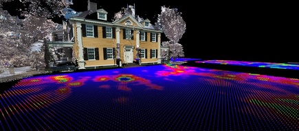
VES specializes in 3D visualization of remotely sensed and excavated archaeological data for a new perspective on non-invasive modeling and analysis of archaeological sites. VES focuses on archaeological landscape visualization and development of technological applications to help solve archaeological problems and for site preservation and planning.
VES focuses research on integrating geophysical data with other types of spatial data through GIS and new methods for 3D data visualization which seeks to seamlessly combine 3D subsurface features, excavation data, and existing environment data. |
Airborne LiDAR
Geophysical Surveys
Metallic Surveys
Terrestrial 3D Laser Scanning
|
|